
In order to contribute to the recovery of agriculture, a wide range of regulatory, economic and social changes must be implemented, but a key piece of the puzzle is technology.
Farmers are integrating satellite imagery, drones, ground sensors, robotics, and data analysis with artificial intelligence (AI) or machine learning (ML) into regenerative or "smart" farming practices. With these modern tools, farmers can optimize their work, combat soil degradation, increase yields, and improve resource efficiency. These technologies offer a type of information that was previously inaccessible, and their use can help farmers take a proactive role in anticipating and adapting to future changes.
Rising agricultural costs and limited access to resources are always a challenge, but the possibilities offered by technology are enormous. Integrating technological advancements can pave the way for sustainable land management and foster agricultural resilience—a ray of hope for a better future. In this article, we will analyze the transformative potential of technology for revitalizing degraded lands, examining some of the available tools and potential strategies.
Smart Farming Tools
Although it is a new field, the smart farming sector, which uses sensing, communication, and analytics technologies to improve the efficiency, productivity, and sustainability of farming techniques, is already growing. It reached a value of $22.65 billion in 2023 and is expected to experience a compound annual growth rate (CAGR) of 13.7% between 2024 and 2030. [footnoteRef:2]
Faced with the sector's ever-increasing challenges, smart agriculture has become a vital initiative. It encompasses a wide range of tools for leveraging the latest and most advanced technology, and is revolutionizing how land use is assessed and improved, resulting in more efficient and sustainable farming practices.
Satellite Imagery:
Despite being physically distant from the ground, satellite imagery is one of the most transformative tools at our disposal. By monitoring vast areas of farmland, which are often very difficult to inspect from the ground, these images offer an aerial perspective of the land and allow us to uncover hidden patterns of erosion, vegetation health, and land use. This information helps drive targeted measures to address the root cause of the problem.
The European Space Agency (ESA) has a long history of supporting smart agriculture; for example, it regularly publishes free data from its satellites. In addition to these precise images, ESA's Soil Moisture and Ocean Salinity (SMOS) mission provides data on soil moisture levels, which farmers can use to plan irrigation and which alerts them to drought or water stress conditions.
Soil Sensors:
Instead of traditional laboratory tests on soil condition, smart soil sensors provide continuous, real-time data on the state of the land. These sensors monitor moisture levels, nutrient content, and pH levels, offering a detailed picture of the soil's condition and its capacity to support plant life. In degraded lands, deploying sensors like the Seeed Studio MODBUS-RTU RS485 Soil Sensor (Figure 1) provides intelligent data that reveals underlying soil problems.
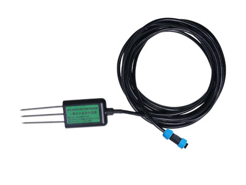
Seeed Studio's humidity and temperature sensors have an IP68 rating, so they can be left on the floor for long periods of time (source: Mouser Electronics)
The sensors combine measurements of humidity, temperature, and electrical current (optional) in the soil to identify problems; this provides intelligent information and allows for better management of resources, especially water.
Intelligent Automation
: Automation in agriculture has opened the door to new possibilities related to efficiency and precision. A multitude of tasks, such as irrigation or pest management, can be automated, contributing to better resource utilization and increased crop health and productivity.
Furthermore, there are complementary applications that can achieve even greater levels of efficiency. For example, agrivoltaic systems (image 2) use mobile and automated solar panels to cover animals and crops, generating energy while protecting or improving growing conditions.
The most important electronic components of these solutions, such as microcontrollers and wireless and radio frequency modules, are constantly evolving, which will contribute to improving the applications and efficiency of automation, as well as reducing implementation costs.
Strategies for improving growing conditions:
When applying regenerative agricultural measures, it is necessary to define some important areas. The initial step is to determine the specific soil problems before establishing its use; that is, whether it will be used for pasture, cultivation, or recreational activities.
Next, it is essential to define the available resources, both economic and physical, for the viability of the planned transformation. Efforts to regenerate the soil and rewilding strategies have had a considerable effect, but there are still limitations that must be taken into account.
Optimizing Soil Flow:
Satellite imagery is essential for soil regeneration and can be used to both monitor progress and plan land flow. Plantations and forests poorly optimized for the soil topography can easily erode and suffer water runoff, causing the soil to lose nutrients. Satellite imagery allows us to reorganize the soil following the Keyline design principle, [footnoteRef:4] which offers many advantages, especially in dry, mountainous pastures. This principle identifies the natural flow of water and optimizes the supply of water and fertilizer in accordance with this natural movement through a terraced design, helping to prevent runoff and reduce resource use.
The report "Case Studies: Regenerative Agriculture in Action" by the European Institute of Innovation and Technology studied the case of a farm in Italy where there was a considerable difference in height between different areas of the pasture: the lower area reached a height of 1.8 m, while on the hills it only reached 70 cm. However, after applying the Keyline design, no noticeable difference was observed
Precision grazing:
Satellite imagery also helps assess the impact of livestock on the soil, making it easier to implement more precise grazing procedures that minimize environmental impact and improve animal welfare. This can be integrated with smart grazing solutions that include precision positioning modules and IoT communication. As a result, farmers can more effectively monitor livestock and increase their access to larger grazing areas.
The u-blox MAX-M10 positioning module boasts a high detection rate and consumes only 25 mW, ensuring long battery life. This device can be combined with a Bluetooth® module, such as the u-blox NORA-B1 Bluetooth 5.2 module, for local IoT communication. Alternatively, the u-blox SARA-R4 series radio frequency module (pictured) offers both LTE mobile positioning and Global Navigation Satellite System (GNSS) positioning in a single module.
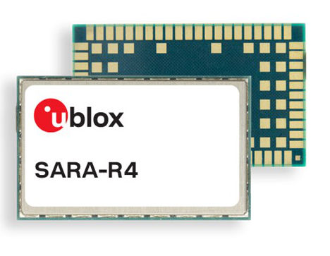
The u-blox SARA-R4 is available in a miniature SARA LGA form factor (26×16 mm and 96 pins) (source: Mouser Electronics)
The implementation of distributed intelligence:
Unlike fixed-threshold systems or multiple linear regressions, an AI system offers a greater level of adaptability and can continue to improve and self-adjust as it acquires more data. One such system is Edge Impulse: a hardware-independent solution that enables the deployment of decentralized intelligence at the edge, rather than in the cloud. This eliminates the need for an internet connection and reduces the number of energy-intensive components.
Edge Impulse technology has been implemented in various hardware, such as the Arduino Edge Control board, to design smart irrigation systems using AA technology. The Arduino controller is specifically designed for outdoor applications, such as smart irrigation or hydroponics, and features sixteen inputs for hydrostatic water level sensors, as well as a 12V, 5Ah battery that can last up to 34 months. It includes Bluetooth connectivity for local communication and can be expanded with 2G/3G/CatM1/NB-IdC, LoRa®, Sigfox, and Wi-Fi® modems by adding compatible Arduino MKR boards. In a practical case study led by Edge Impulse, the Arduino controller was combined with a set of relays and hydrostatic sensors to establish a control and feedback system for smart crop irrigation, aiming to maximize crop yields, minimize soil degradation, and reduce water waste.
Resilient Farms:
Smart soil regeneration involves a combination of tools and strategies to restore soil to a harvestable state. In soil management, solutions like the one developed in the Edge Impulse case study allow for the controlled delivery of resources such as water and fertilizer, while also providing a complex feedback mechanism within the context of a larger regeneration project.
Smart sensors are an effective starting point for identifying significant soil health issues, but they are part of a larger framework of continuous improvement. Visual analysis, whether through direct observation or satellite imagery, helps farmers pinpoint specific areas where improved soil management and the allocation of water, plants, and livestock could yield positive results. Following these processes, by collecting data from soil sensors and smart irrigation systems at these locations, farmers can determine the appropriate levels of variables such as optimum moisture content or pH for that particular plot of land.
This data can be used to develop more complex predictive models, capable of taking into account future weather conditions, animal movement, and other factors. In turn, this facilitates meticulous management of land resources, ensuring they are supplied only when needed, minimizing losses, and improving overall efficiency.
Optimizing the Future:
Around the world, the combination of cutting-edge technology with the agricultural sector's remarkable work ethic is already having a considerable impact. According to the Boston Consulting Group (BCG), regenerative practices can increase a farm's profitability by 70 to 120 percent, as well as reduce fertilizer use by 50 percent and pesticide use by up to 75 percent—all while maintaining or increasing productivity. [footnoteRef:7]
Smart agriculture allows us to work more closely with nature to counteract the impact of over-cultivation and extreme weather conditions. Technologies such as soil sensors and satellite imagery help us understand problems on the ground across vast areas in ways that would be impossible with laboratory testing. Furthermore, when these systems remain in place, they can be used to continuously manage the supply of water, pesticides, and fertilizers in a way that adapts to changes in soil and weather conditions, helping us meet future food demands more effectively.
Author: Mark Patrick, Director of Technical Content, EMEA, Mouser Electronics